Solva - From 'A Topographical Dictionary of Wales' (1849)
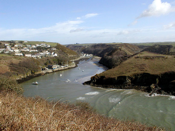
SOLVA, a small sea-port, in the parish of Whitchurch, union of Haverfordwest, hundred of Dewisland, county of Pembroke, South Wales, 12 miles (N. W. by W.) from Haverfordwest; containing 596 inhabitants. This place derives its name from its situation near the mouth of the small river Solva, which here discharges itself into the northern part of St. Bride's bay. It first came into notice from the great demand for shipping during the last war, and the convenience of its harbour; and, from one of the poorest hamlets in this part of the principality, has within the last sixty years risen into a flourishing little town. The houses are of very neat appearance, but are built without any regard to regularity of plan, and only those which are situated in the lower part of the valley, in a direction parallel with the river, have the form of a street. Within a few hundred yards of the original buildings another small town has been erected, occupying the height above the vale, and from that circumstance called Upper Solva. The aspect of the whole is highly interesting; the cottages are of a comfortable description, and the gardens, laid out in terraces on the acclivity of the hill, and commanding a fine view of the sea, are pleasing and picturesque.
The harbour is sheltered from the waves of St. Bride's bay by a singular bend at the mouth, and by a large pyramidal rock, which divides the entrance into two narrow passages. It is accessible to ships of five hundred tons' burthen, and in cases of emergency ships of a thousand tons might anchor; but the great rock at its mouth, and the high lands which surround it, appear at a distance as one entire cliff, and render the approach somewhat dangerous, owing to the difficulty in discerning the entrance. Many nautical men are of opinion that, at a very small expense, such improvements might be made as would render it one of the safest and most commodious havens on the coast. There were formerly about thirty vessels of various descriptions belonging to the port, of from twenty to two hundred and fifty tons' burthen; but that number is greatly reduced, and at present there are only four brigs, varying from one hundred and fifty to two hundred tons' burthen, and a few small craft of from twenty to forty tons. The staple trade of the port is in corn, of which considerable quantities are shipped for the English markets; and in limestone and coal, which are brought from Milford Haven: the limestone is burnt into lime at some kilns near the entrance of the town, for the supply of the surrounding districts. The sand of the harbour, possessing saline properties, is raised in tolerable quantity at low water, and landed on the quay, whence it is taken away by the farmers in the neighbourhood, and used as a manure. A small market is held weekly on Friday. On the ridge called the Gribyn, which bounds the valley of the Solva on the east, are traces of various intrenched encampments; and at the southern extremity, towards the sea, is a circular intrenchment, surrounded by a rampart of loose stones, and supposed to be of British origin.�See Whitchurch.
In this town, until transferred to Milford, was the establishment belonging to the lighthouse upon the "Smalls," a cluster of dangerous rocks, distant about eighteen miles from the Welsh coast, bearing from St. Anne's Point W. N. W., from St. David's W. S. W., and from Gresholm W.� N. These rocks form three distinct reefs, extending parallel to each other in a direction from north-east to south-west, for three-quarters of a mile; the entire breadth in a transverse direction is about a quarter of a mile. The greater number of them are above water, while others are visible only at half tide; on the largest of the former is the lighthouse, the plan of which was first suggested by Mr. Philipps of Liverpool, and the building erected by Mr. Whitesides, of the same place. It was completed in the year 1775, and its stability was proved by the architect himself, who, in company with two other persons, passed the following winter in it. The lighthouse is an octagonal building, resting upon eight strong oak piles at the angles, and one in the centre; the piles at the north and north-east angles are stayed, to resist the violence of the waves, which sometimes strike the edifice on the opposite side with the whole force of the Atlantic swell. The rock on which it is built is twelve feet above the level of the sea at high water, and the lantern has an elevation of seventy feet; it is lighted by eighteen argand lamps, and in clear weather the light, which is of a red colour, is seen at the distance of five or six leagues, having the appearance of a star of the first magnitude. Beneath the lantern are the store-room and the apartments for the men, who are always three in number, and are furnished with a supply of provisions and stores for six months, as it frequently happens that for many weeks together, during the winter, no boat can reach the rock. The erection of a lighthouse on these dangerous rocks has been attended with the greatest benefit to the navigation of the Channel, many lives and much property having been saved since the design was carried into effect. The Smalls, it is said, belong to no parish, nor are they within any county; but they are nearest to the Welsh coast, and the inhabitants of the lighthouse are considered as parishioners of Whitchurch. |